RBSE Class 6 Social Science Chapter 1 Question Answer Locating Places on the Earth
Start practicing theRBSE Solutions Class 6 Social Scienceand Class 6 SST Chapter 1 Locating Places on the Earth Question Answer to consolidate your knowledge effectively.
Locating Places on the Earth Class 6 Questions and Answers
Locating Places on the Earth Class 6 Question Answer (InText)
Page 7
Question 1.
What is a map and how do we use it? What are its main components?
Answer:
Map is a representation, or a drawing of some area. A map is like a treasure guide, it shows where things are and how to get them. Map can represent a bigger area or a small area.
There are three important components of a map : (i) Distance (ii) Direction (iii) Symbol.
Question 2.
What are coordinates? How can latitude and longitude be used to mark any location on the Earth?
Answer:
A system of coordinates is used in the world of maps to determine the location of any place on a map. Latitudes and Longitudes are two coordinates of a place together.
Every place on the Earth has a location. It can be marked with the help of latitudes and longitudes. Both these imaginary lines together constitute a grid. We can locate and identify the location of any place on the earth with grid lines.
Question 3.
How are local time and standard time related to longitude?
Answer:
Time of a particular place is known as local time. The meridian which passes through Greenwich near London is called the Prime Meridian. Its value is 0° longitude. Hence 0° longitude is related to standard time. The places situated on the same longitude will have the same time which is called the local time of all these places.
For example, when the Prime Meridian has the Sun at the highest point in the sky all the places along this meridian will have mid-day. The places which are located east of Greenwich there time will be ahead of Greenwich mean time. The places which are located at west of Greenwich there time will be behind. The reasons behind that the Earth rotates from west to east.
The Earth rotates one degree in four minutes.
When it is 12 Noon at Greenwich, the time at 15° E in Greenwich will be 60 minutes or 1 hour (15 × 4 = 60). One hour ahead of Greenwich time would be 1:00 pm.
Similarly, if we move 15° W to the Greenwich then time will be one hour behind and it will be 11 am.
Page 9
Question 1.
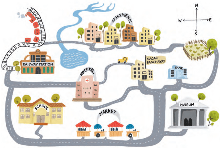
On the map in Fig. 1.1 given on page 8—
1. Mark the hospital.
Answer:
[Mark yourself.]
Question 2.
What is the meaning of the blue- coloured areas?
Answer:
Blue coloured area is used to show water bodies such as river, pond etc.
Question 3.
Which is farther away from the railway station—the school, the Nagar Panchayat or the public garden?
Answer:
The public garden is farther away from the railway station.
Page 10
Question 1.
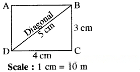
Draw a simple map of a school’s playground. Let us assume it is a rectangle, 40 m in length and 30 m in width. Draw it precisely with your ruler on a scale of 1 cm = 10 m.
Answer:
Question 2.
Now measure the diagonal of the rectangle. How many centimeters do you get? Using the scale, calculate the real length of the playground’s diagonal, in meters.
Answer:
Length of diagonal = 5 cm
Real length of playground’s diagonal will be = 5 × 10 = 50 meters.
Page 11
Question 1.
Consider the map of the small city again (Page 8, Fig. 1.1). Identify the correct and incorrect statements in the list below :
(i) The market is north of the hospital.
(ii) The museum is southeast of the bank.
(iii) The railway station is northwest of the hospital.
(iv) The lake is northwest of the apartment blocks.
Answer:
(i) Incorrect (ii) Correct (iii) Correct (iv) Incorrect
Page 17
Question 1.
If the globe or atlas in your class has well-marked latitudes and longitudes, try to note down approximate values of the latitude and longitude of : (i) Mumbai (ii) Kolkata (iii) Singapore (iv) Paris.
Answer:
The approximate coordinates of these cities are :
(i) Mumbai: 19°N latitude, 72.8°E longitude – It lies along the west coast of India.
(ii) Kolkata : 22.6°N latitude, 88.4° E longitude, located in eastern India.
(iii) Singapore : 1.3°N latitude, 103.8°E longitude, near the equator in Southeast Asia.
(iv) Paris : 48.9°N latitude, 2.4°E longitude, situated in northern France.
Page 21
Question 1.
Two friends, one sitting in Porbandar (Gujarat) and the other in Tinsukia (Assam), are speaking on the phone late afternoon. The latter remarks that the sun has set in Assam and it’s now dark. The former is surprised and says, “But it’s still full daylight here!” Explain why. And, as a class activity, calculate the difference in local time between those two cities. (Hint: for now, consider the difference in longitude between Porbandar and Tinsukia to be 30°; later, you can find out the precise value.)
Answer:
Porbandar (Gujarat) is towards the west of Tinsukia (Assam). There is difference of 30° in longitude between the two places. If we move towards west time gets reduced by 4 minutes per T. Hence here the difference in time will be 2 hours (30 × 4 = 120 minutes of 2 hours).
Therefore, local time of Porbandar will be 2 hours behind Tinsukia. The earth rotates from west to east and completes one rotation in 24 hours. This entire rotation is of 360°. It means earth rotates 15° per/hour.
Question 2.
Return to the two friends sitting in Gujarat and Assam. Use this example to explain the difference between local time and standard time.
Answer:
The earth rotates from west to east. Hence the places East of Greenwich there time will be ahead of standard time and those which are west of Greenwich there time will be behind of standard time.
For example : If it is 12 pm or noon at Greenwich it is 1 pm, local time at 15° E, 2 pm at 30°E, and so on. But going westward it is the other way round—11 am local time at 15°W, 10 am at 30° W, etc.
Class 6 SST Locating Places on The Earth Question Answer (Exercise)
Question 1.
Returning to page 10 and to Fig. 5.2 in Chapter 5 of this textbook, taking the scale to be 2.5 cm = 500 km, calculate the real distance from the estuary of the Narmada River to the estuary of the Ganga river. (Hint : round off your measurement on the map to an easy number.)
Answer:
As per detail given in Fig. 5.2 of this textbook the distance from the estuary of the Narmada river to the estuary of Ganga river is 10 cm.
In this context the scale is 2.5 cm = 500 km. So, the real distance between both the 500 × 10/2.5 km
It means 500 × 4 = 2000 km
Question 2.
Why is it 5:30 pm in India when it is 12 pm or noon in London?
Answer:
Indian Standard Time (1ST) is 5 hours 30 minutes ahead of the local time at Greenwich it is the reason that when it is 5.30 pm in India then it is 12 pm or noon in London.
London is in England the prime meridian of England starts from Greenwich, which is zero degrees.
The Indian Standard Meridian is located 82½° E of the Prime Meridian. Thus the Indian standard is ahead of Greenwich lime.
Question 3.
Why do we need symbols and colours in the map?
Answer:
Symbols give much information in a limited space and with the help of symbols, we can draw maps and read them easily. Hence, we need symbols and colours in the map.
Question 4.
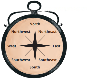
Find out what you have in the eight directions from your home or school.
Answer:
Students will do themselves.
Hint:
Question 5.
What is the difference between local time and standard time? Discuss it in groups, with each group writing an answer in 100 to 150 words. Compare the answers.
Answer:
The time of a particular place is local time while the meridian passing through Greenwich mean time is considered as Standard Time of a place. Its value is 0° longitude.
Example : The Indian Standard Meridian is 82°30°E and 1ST is 5 hours 30 minutes ahead of the Greenwich Mean lime.
Question 6.
Delhi’s and Bengaluru’s latitudes are 29°N and 13°N; their longitudes are almost the same, 77°E. How much will be the difference in local time between the two cities?
Answer:
There will no difference in local time between the two cities because their longitudes are almost the same and longitudes are used to determine the local time of a place.
Question 7.
Mark the following statements as true or false; explain your answers with a sentence or two.
(i) All parallels of latitude have the same length.
(ii) The length of a meridian of longitude is half of that of the Equator.
(iii) The South Pole has a latitude of 90°S.
(iv) In Assam, the local time and the 1ST are identical.
(v) Lines separating the time zones are identical with meridians of longitude.
(vi) The Equator is also a parallel of latitude.
Answer:
(i) False, All parallels of latitude do not have the same length. The Equator is the largest circle. The circles marked by the parallels of latitude grow smaller as we move northward or southward.
(ii) True, Longitudes are all half circles running from one pole to another they are drawn from north pole to south pole and their length is half from equator because at equation complete circle is formed.
(iii) True, By convention the equator is latitude 0° (zero degree) while the latitudes of the two poles are 90° North and 90° South respectively; this is noted 90°N and 90°S.
(iv) True, Indian Standard Time is 5 hours 30 minutes ahead the local time at Greenwich hence in Assam the local time and 1ST are identical.
(v) True, Time zones are spaces of 156 of longitude and change by 1 hour with regard to the local time. As the circle has 360°, there are 24 time zones pertaining to 24 hours that are in a day. Thus time zones are identical with meridian of longitude – 0°, 15°, 30°, 45°, 60°, 75° till 180° Eastwards and Westwards.
(vi) True, The Equator is also a parallel of latitude. It is also known as the Great Circle.
Question 8.
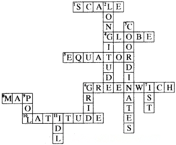
Solve the crossword below :
Across :
1. Lets you squeeze a huge area into your map
4. A convenient sphere
5. The longest parallel of latitude
6. The place the Prime Meridian is attached to
8. So convenient to find your way
10. A measure of the distance from the Equator
Down :
2. A measure of the distance from the Prime Meridian
3. These two together allow us to locate a place
6. What latitudes and longitudes together create
7. The time we all follow in India
9. These two are poles apart
11. An abbreviation for a line across which the day and date change
Answer:
Locating Places on the Earth Class 6 Extra Questions and Answers Social Science Chapter 1
Multiple Choice Questions
1. Mountains, Oceans and Rivers etc. are shown with the help of ……………….. maps.
(a) Thematic
(b) Political
(c) Physical
(d) Population
Answer:
(c) Physical
2. ……………….. show details of countries, states, boundaries, cities etc.
(a) Political maps
(b) Physical maps
(c) Thematic maps
(d) None of these
Answer:
(a) Political maps
3. Which among the following is not a component of map?
(a) Distance
(b) Direction
(c) Symbol
(d) Scale
Answer:
(d) Scale
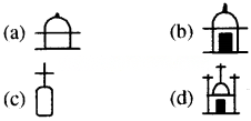
4. Which of the following is a symbol of chhatri?
Answer:
a
5. How are latitudes expressed?
(a) In feet
(b) In meters
(c) In degrees
(d) In centimeters
Answer:
(c) In degrees
6. How many degrees of latitude does the equator represent?
(a) 0°
(b) 90°
(c) 180°
(d) 360°
Answer:
(a) 0°
7. When it is 12:00 noon at Greenwich, what will be the time at 180° meridian?
(a) Morning
(b) Evening
(c) Noon
(d) Mid-night
Answer:
(d) Mid-night
8. How many days does the date change when we cross the International Date Line?
(a) 10 days
(b) 1 day
(c) 2 days
(d) 4 days
Answer:
(b) 1 day
9. How many minutes does the Earth takes to rotate one degree?
(a) 15 minutes
(b) 4 minutes
(c) 30 minutes
(d) 6 minutes
Answer:
(b) 4 minutes
10. ……………….. is considered as the Indian Standard Meridian?
(a) 68° E
(b) 90° E
(c) 82½° E
(d) 8½° E
Answer:
(c) 82½° E
Fill in the blanks
1. A map is a ………………….. of some area.
Answer:
representation
2. There are three components of map distance, direction and ………………….. .
Answer:
symbols
3. The actual distance between two points represented on the map depends on the ………………….. .
Answer:
scale
4. A ………………….. will better represent the geography of the earth than a flat map.
Answer:
globe
5. The Prime Meridian was fixed at Greenwich, the opposite line at- approximately 180° longitude is called the ………………….. .
Answer:
International Date Line
6. ………………….. is the largest circle on globe.
Answer:
Equator
State whether True or False
1. A globe shows both the parallels of latitude and meridian of latitude.
Answer:
True
2. North and South pole have warm climate.
Answer:
False
3. The Meridians of longitude are semicircle moving from one pole to another.
Answer:
True
4. The Prime Meridian divides the earth into the Northern hemisphere and Southern hemisphere, while the equator divides it into the eastern and western hemisphere.
Answer:
False
Match the following
Question 1.
I | II |
1. Natural Features | (a) Political maps |
2. Boundaries of Countries | (b) Physical maps |
3. Distribution of Industries | (c) Model of Earth |
4. Globe | (d) Thematic maps |
Answer:
I | II |
1. Natural Features | (b) Physical maps |
2. Boundaries of Countries | (a) Political maps |
3. Distribution of Industries | (d) Thematic maps |
4. Globe | (c) Model of Earth |
Question 2.
I | II |
1. The semi circle moving | (a) Latitudes from one pole to another |
2. A line running from | (b) Longitudinal east to west parallel Meridian to the equator |
3. The main meridian used | (c) The Greenwich in ancient astronomy Meridian |
4. The present center for | (d) The Ujjayini measuring longitude Prime Meridian |
Answer:
I | II |
1. The semi circle moving | (b) Longitudinal east to west parallel Meridian to the equator |
2. A line running from | (a) Latitudes from one pole to another |
3. The main meridian used | (d) The Ujjayini measuring longitude Prime Meridian |
4. The present center for | (c) The Greenwich in ancient astronomy Meridian |
Very Short Answer Type Questions
Question 1.
What is Map?
Answer:
Map is a representation of some area. It may be a small area of bigger area.
Question 2.
What is the map called showing natural features of the Earth?
Answer:
Physical Map.
Question 3.
What is the map called showing details of countries, state, cities etc.?
Answer:
Political Map.
Question 4.
Define Thematic maps.
Answer:
Thematic maps shows specific kind of information e.g. distribution of industries, population.
Question 5.
How many types of maps are there?
Answer:
(1) Political map (2) Physical map (3) Thematic map
Question 6.
On what does the distance between any two points marked on the map depend?
Answer:
It depends on the scale that the map is using.
Question 7.
Write any two features of map.
Answer:
- Maps provide us information of distance between two places.
- They tell us about directions.
Question 8.
How is the North direction marked on a map?
Answer:
It is marked with alphabet N above on the right side with an arrow.
Question 9.
What is used to show different features of land in a map?
Answer:
Symbols
Question 10.
Define the term equator.
Answer:
It is an imaginary line divides the globe into two equal halves Northern Hemisphere and Southern Hemisphere.
Question 11.
‘Zero degree’ longitude is also known as the Prime Meridian or Greenwich Meridian. Give reason.
Answer:
Zero degree longitude passes through Greenwich, an area of London in England. In 1884 some nations decided that it would become the international standard for the prime meridian and it is marked as zero degree longitude.
Question 12.
What effect does the length of latitudes has moving from north and south of the equator?
Answer:
Parallels of latitudes grow smaller as we move northward and southward of the equator.
Question 13.
How much does the earth rotate in one hour?
Answer:
The earth rotates 15° in one hour.
Question 14.
Which co-ordinate divides the earth into the eastern and western hemisphere?
Answer:
The Prime Meridian
Question 15.
What is latitudinal extent of India?
Answer:
It is approx. 8° N to 37°N.
Question 16.
What is the longitudinal extent of India?
Answer:
It is 68°E to 97°E.
Question 17.
What is Indian Standard Time?
Answer:
82½°E is Indian Standard Time.
Question 18.
Indian Standard Time is how many minutes ahead of Greenwich Mean Time?
Answer:
Indian Standard Time is 5 hours 30 minutes ahead of Greenwich Mean Time.
Question 19.
What do you understand by the International Date Line?
Answer:
The Prime Meridian was fixed at Greenwich the opposite line at approximately 180° longitude is called the International Date Line.
Question 20.
How much time the Sun take to reach from one longitude to another?
Answer:
4 minutes.
Short Answer Type Questions
Question 1.
How is a scale useful for a map?
Answer:
The actual distance between the two points represented on the map depends on the scale that the map is using. If we know the scale of a map then we can identify the distance between two places.
Question 2.
What is meant by symbols of map?
Answer:
Symbols are important components of map. These are used to show buildings, roads, railway lines, rivers, ponds, forests in the map. With the help of these symbols various features can be shown in the limited space available on the map. To make maps more easily understood by variety of users, map makers use specific symbols.
Question 3.
How can you determine directions using a map?
Answer:
We can find an arrow printed on the right comer of the map marked with a letter ‘N’ pointing towards North direction. After knowing the north direction, we can easily find out other directions such as east, west, north.
Question 4.
Enlist any four features of a globe.
Answer:
- A globe can better represent the geography of the earth.
- It can be rotated to view different parts of the earth.
- There are different types of globe available.
- Globes show accurate proportions of continent and oceans.
Question 5.
What do you understand by the North Pole and South Pole?
Answer:
The Equator is 0° latitude.
- All parallels north to equator are called north latitude and all parallels in the south of the equator is called south latitudes.
- Since the distance from the equator to the North or South pole is one-fourth of a circle of the earth, it measures ¼th of 360 degrees i.e. 90°. So, 90 degree north latitude (90°N) marks the Nouth Pole and 90 degree south latitude (90°S) marks the South Pole.
Question 6.
How does latitude influence the climate of an area?
Answer:
Around the equator, the climate is generally hot and it is known as Torrid zone. As we move away from the equator towards one of the two poles the climate becomes moderate because sun rays fall slanting here. Closer to the North or South Pole the climate goes colder because the Sun does not rise much here. It means as latitude increases climate became frigid.
Question 7.
How does the equator divide the Earth into two hemispheres?
Answer:
All parallels north of the equator are called ‘north latitudes’. Similarly all parallel south of the equator are called south latitudes. The equator divides the globe into two equal halves; these are the Northern Hemisphere and Southern Hemisphere. The alphabet ‘N’ is used to represent north latitude and ‘S’ is used to show the south latitude.
Question 8.
What is longitude?
Answer:
An imaginary line passes through the Greenwich near London is called the Prime Meridian, its value is 0° longitude. Longitude is measure of the distance from the Prime Meridian if we move along the equator. Longitude too is measured in degrees westward or eastward, it increases in value from 0° to 180°, with the letter ‘W’ or ‘E’ added.
Long Answer Type Questions
Question 1.
Explain the various types of maps.
Answer:
The different types of maps are :
1. Physical maps, which mainly show some natural features such as mountains, oceans and rivers.
2. Political maps, which show details of countries or states, boundaries, cities, etc. For instance, a map of India with all its States, Union Territories and their capitals.
3. Thematic maps : Maps which provide specific kind of information are called Thematic maps such as weather, rainfall, forests, industries etc.
Question 2.
How are directions shown in the map?
Answer:
The four arrows at the top right of the map shows four directions. The top arrow shows north direction and moving clockwise, east, south and west directions can be identified. These are called cardinal directions. Other than these intermediate directions are also used Northeast (NE), Southeast (SE), Southwest (SW) and Northwest (NW). Most maps simply have an arrow marked with the letter ‘N’, which points to the north direction.
Question 3.
What is scale? Explain with example.
Answer:
A scale is a ratio between the actual distance on the ground and the distance shown on the map.
Example : Suppose the scale of is 1 cm : 10 km. This means that a distance of 1 cm between two points on the map has a distance of 10 km between the same two places on the ground.
Question 4.
How does a globe help in understanding the Earth’s geography?
Answer:
Globe is a true model of the Earth. The shape of globe and the Earth is like a sphere, hence a globe will better represent the geography of the Earth than a flat map. Globe can show countries, continents, oceans in their accurate shape. Globe has a needle in tilted manner called its axis. The two points on the globe through which the needle passes indicate two poles.
Question 5.
Highlight the key features of the equator.
Answer:
The equator is the most significant latitude. It divides the Earth into two halves- the Northern Hemisphere and the Southern Hemisphere. It forms the largest circle around the Earth.
As we move northward or southward from the equator, the circles marked by the parallels of latitude grow smaller. Latitude measures distance from equator only.
Question 6.
What do you understand by the term ‘Latitude’? Write key features of latitudes.
Answer:
Latitudes : Imaginary lines drawn from east to west parallel to the equator is called ‘latitude’.
Features :
- The latitudes are parallel to each other.
- They form circles around the Earth.
- Latitudes are measured in degrees.
- The equator is zero degree latitude which divides the Earth into two equal halves : the Northern Hemisphere and the Southern Hemisphere.
- 90° North latitude (90° N) marks the North Pole and 90° South latitude (90° S) marks to South Pole.
- Degrees of latitudes increase while moving away from the equator and moving towards the poles. ‘
- Latitude measures distance from equator.
Question 7.
Define International Date Line. How does crossing the International Date Line impact the calendar date?
Answer:
International Date Line : The Prime Meridian was fixed at Greenwich, the opposite line-at approximately 180° longitude is called the International Date Line.
The +12 and -12 time zones touch each other at International Date Line. If we cross it by a ship or a plane we need to change the date in our watch. If we cross it travelling eastwards, we subtract a day such as from Monday to Sunday, if we cross it travelling westwards we add a day such Sunday to Monday.
Essay Type Questions
Question 1.
Explain in brief the components of a map.
Answer:
There are three main components of a map : distance, direction and symbol.
1. Distance : It is an important component of a map. In a map the distance on the ground is represented by a reduced scale so the actual distance between two points represented on the map depends on the scale that the map is using.
2. Direction : The North direction is shown in the map with an arrow printed on the right hand corner. With the help of this other directions such as east, west, and south can be identified easily.
3. Symbols : Symbols are used in various maps to show different features such as mountains, forests, roads, lakes etc. In that way numerous details can be shown in the limited space available on the map.
Question 2.
Mention the key features of longitudes.
Answer:
The features of longitudes : The features of longitudes are—
- These are imaginary semicircular lines running from North Pole to South Pole.
- Longitudes are equal in length but not parallel.
- Longitudes are semicircles.
- The Prime Meridian divides the earth into two equal halves : the eastern hemisphere and the western hemisphere.
- Meridians of longitude are used to determine time and dates.
- The distance between any two meridians of longitudes decreases when we move towards poles and ultimately it becomes zero at the poles.
- 180° E and 180° W of the Prime Meridians are used in calculations.
Question 3.
What do you know about Local Time? How is it calculated?
Answer:
Local Time : The Time of a particular place is known as Local Tir e.
Calculation of Local Time
- Time is calculated with the help of meridians. The meridian passing through Greenwich an area of London in England is considered the international standard for the prime meridian. It is marked as 0° longitude.
- If it is noon at Greenwich then all the places located at this meridian will have noon only.
- The Earth rotates from west to east direction, hence the places located to the east of Greenwich will have their time ahead of Greenwich time and those which are in west will have their time behind.
- The Earth completes one rotation in 24 hours, i.e. 360°. It means it takes one hour to rotate 15° and 4 minutes in the rotation of 1 degree.
In this way when it is 12 noon at Greenwich, it is 1 pm local time at 15° E. But going westward it is the other way round-11 am local time at 15° west. In the similar way when it is 12 noon at Greenwich it will be mid-night at 180° meridian.
Question 4.
What will be the time in Delhi when it is 12 noon on the prime meridian?
Answer:
Longitude of Delhi = 11° E
Longitude of the Prime Meridian = 0°
Difference of longitude of both the places = 77° – 0° = IT
Time difference of 1 longitude = 4 minutes Hence, time difference for the 77° longitude = 77 × 4 = 308 minutes.
308 minutes = 5 hours and 8 minutes
The time at Delhi will be 5 hours and 8 minutes ahead of the Prime Meridian because Delhi is located East of the Prime Meridian. Hence, time in Delhi will be 12 + 5.08 means 5.08 PM.
Locating Places on the Earth Class 6 Notes Social Science Chapter 1
Map and its Components :
- Map is a representation, or a drawing of some area. A map is like a treasure guide, it shows where things are and how to get them.
- We can see four arrow in a map showing four specific directions and make maps more helpful. These four directions are : Hast, West, North and South.
- Map can represent a bigger area and a small area.
- There are several kinds of maps : (i) Physical maps (ii) Political maps (iii) Thematic maps
- There are three important components of a map : (i) distance (ii) direction (iii) symbol
Mapping the Earth : The globe and the Earth have the same spherical shape. Hence, the globe represents the Earth.
(i) Understanding Coordinates : A system of coordinates is used in maps to determine the location of any place on map. Eatitude and longitude together are the two coordinates of a place on the globe. With the help of these we can identify any place on the earth.
(ii) Latitudes : The equator is a line that runs around the center of Earth at zero degree latitude. It is halfway between the North and the South poles.
An imaginary line that runs east and west, parallel to the equator is known as latitude. The latitudes are parallel to each other, therefore, these are called the parallels of latitudes. Latitude draws a circle around the Earth. The largest circle is the equator.
Ilie circles marked by the parallels of latitude grow smaller as we move northward or southward. The equator is 0° latitude. The latitudes of the two poles are 90° South and 90° North respectively, this is noted 90°S and 90°N
Around the equator, the climate is generally hot. As we move away from the equator towards the poles, climate becomes more moderate. Closer to the North or South Pole, the climate grows colder.
(iii) Longitudes :
- Longitudes are imaginary semi-circular lines running from North to the South Poles.
- The meridian passing through Greenwich, an area of London in England is considered the International standard for the Prime Meridian. It is marked as 0° longitude.
- The parallels of latitude and the meridians of longitude together constitute a grid on the . globe. They are also known as grid lines. Every place on the earth has a location and it can be easily defined with the help of grid lines.
Understanding Time Zones :
- Moving eastward from the Prime Meridian we get 0°, 15°E, 30°E, 45°E and so on every 15° up to 180° E. Example : If the local time at 15°E, is 1:00 pm then at 30°E, it will be 2 pm but going westward it is the other way round. The same method can be used to calculate the local time of any place on the earth.
- Indian Standard Time is 5 hours 30 minutes ahead of the local time at Greenwich.
- The Prime Meridian was fixed at Greenwich the opposite line at approximately 180° longitude—is called the International Date Line. The date changes by 1 day when we cross the International Date Line.