Chapter 10 Transport And Communication
Textbook Questions Solved
1. Choose the right answers of the following from the given options:
Question 1.(i)
In how many zones has the Indian Railways system been divided?
(a) 9
(b) 12
(c) 16
(d) 14
Answer:
(c) 16
Question 1.(ii)
Which one of the following is the longest highway of India?
(a) N.H.-l
(b) N.H.-6
(c) N.H.-7
(d) N.H.-8
Answer:
(c) N.H.-7
Question 1.(iii)
On which river and between which two places does the National Water Way No. 1 lie?
(a) The Brahmaputra, Sadiya-Dhubri
(b) The Ganga, Haldia-Allahabad
(c) West Coast Canal, Kottapuram to Kollam
Answer:
(b) The Ganga, Haldia-Allahabad
Question 1.(iv)
In which of the following year, the first radio programme was broadcast?
(a) 1911
(b).1936
(c) 1927
(d) 1923
Answer:
(d) 1923
2. Answer the following questions in about 30 words:
Question 2.(i)
Which activity does transportation convey? Name three major modes of transportation.
Answer:
Transport conveys the basic activity of mobility. Mobility is a basic need of humans which helps in trade and other activities. Transport is instrumental in bringing out about increased mobility. The three major modes of transportation are land, water and air. Land includes roadway, railway and ropeway.
Question 2.(ii)
Discuss advantages and disadvantages of pipeline transportation.
Answer:
Pipeline transportation is a newer development in the field of transportation. Advantages:
- Liquids and gases can be transported easily at low costs. Even solids can be transported in form of sluriy.
- No need of fuel is required. It is an eco friendly method. Gradient plays the main role in transportation of the material.
- Pipelines can be laid in the high altitude, rugged areas, even under the sea.
- Material can be transported between distant areas continuously without aid of human agent carrying it from one place to another.
Disadvantages:
- Cost of laying the pipelines is very high. People cannot be transported.
- Leakage in the pipelines can cause serious disasters especially in case of transportation of material like petroleum.
- Pipelines are very probable target of terrorist attacks; therefore, safety is major issue.
- All solid substances cannot be transported.
Question 2.(iii)
What do you mean by ‘communication?
Answer:
Communication is transmission of facts, words and information using various means of communication. It is disseminating of ideas, facts, information and knowledge through writing, words. Communication has been present since very initial stages of human development. Earlier there were primitive means of communication like beating of drums, sparrows etc. Now with communication revolution modem methods of communication like Internet, mobile telephony are widespread and have made communication over long distances easier and faster.
Question 2.(iv)
Discuss the contribution of Air India and Indian in the air transport of India.
Answer:
Air transport in India made a beginning in 1911 when airmail operation commenced over a little distance of 10 km between Allahabad and Naini. But its real development took place in post-independent period. The air transport in India is managed by two corporations, Air India and Indian Airlines after nationalization. Air India provides international service for both passengers and cargo. In 2005, it carried 12.2 million passengers and 4.8 lakh metric tonnes of cargo. Indian looks after air transport at national level. In 2005, domestic movement involved 24.3 million passengers and 20 lakh metric tonnes of cargo.
The country’s largest state-owned domestic carrier, Indian Airlines dropped the word ‘Airlines’ from its name and is known as ‘Indian’ w.e.f. December 8,2005. The new brand name ‘Indian’ now appears on both sides of the fuselage. The logo on the orange tail depicting ‘IA’ has also been changed. It has been replaced by a new logo which is a partly visible blue wheel and is inspired by the Sun Temple at Konark (Odisha), symbolising timeless motion, convergence and divergence. It also embodies strength as well as trust that has stood the test of time.
3. Answer the following questions in about 150 words:
Question 3.(i)
Which are the chief means of transportation in India? Discuss the factors affecting their development.
Answer:
The important means of transport in India are—Land, air and water. Each mode of transportation contributes to the development of economy. Each provides a strong support for setting up industries and link even the remotest areas. All the means of transport compete and compliment each other.
- Land transport comprises road, rail and pipeline. Use of railways for carrying heavy and bulky goods along with the large number of passengers over long distances has led to the development of a dense network of railways. Within the country the network is relatively less dense in the hilly, forested and desert areas. Roads play an important role in linking the interior areas with the markets and urban centres. Their importance in facilitating door-to- door services over short distances has led to development of a well knit network of roadways.
- Water transport is an ideal means for engaging in international trade through long and indented coastline of India. Inland waterway also links the different regions within the countiy efficiently. It is the cheapest means for bulky cargo.
- Air transport has become very important means of rapid and frequent movement of people and light cargo over long distances. Role of private airlines has made the air transport trickle down to wider sections of economy. Budgets Airlines have changed the aviation scenario in India. Air transport is important in inaccessible areas, during calamities and for rapid connectivity.
Question 3.(ii)
Give a detailed account of the development of railways in India and highlight their importance.
Answer:
Indian railways network is one of the longest in the world. It facilitates the movement of both freight and passengers and contributes to the growth of economy. Indian Railway was introduced in 1853, when a line was constructed from Bombay to Thane covering a distance of 34 km.
It is the largest government undertaking in the countiy. Its network length is 63,221 km. Its very large size puts lots of pressure on a centralized railway management system. Thus, in India, the railway system has been divided into sixteen zones. Indian Railways has launched extensive programme to convert the metre and narrow gauges to broad gauge. Moreover, steam engines have been replaced by diesel and electric engines. This step has increased the speed as well as the haulage capacity.
The replacement of steam engines run by coal has also improved the environment of the stations. Metro rail has revolutionized the urban transport system in Kolkata and Delhi. Replacement of diesel buses by CNG run vehicles along with introduction of metro is a welcome step towards controlling the air pollution in urban centres.
Areas around towns, raw material producing areas and of plantations and other commercial crops, hill stations and cantonment towns were well-connected by railways from the British colonial era. These were mostly developed for the exploitation of resources. After the Independence of the country, railway routes have been extended to other areas too. The most significant development has been the development of Konkan Railway along the western coast providing a direct link between Mumbai and Mangalore.
Railway continues to remain the main means of transport for the masses. Railway network is relatively less dense in the hill states, north eastern states, central parts of India and Rajasthan.
Question 3.(iii)
Describe the role of roads in the economic development of India.
Answer:.
Roads serve as the lifeline of Indian trade. They connect the consumers with producers that is they connect urban and rural centers. Rural centers are producers of agricultural goods which are consumed by them and are transported to urban centers because they do not have production of agricultural commodities. On the other hand urban centers produce consumer products and supply them to the rural areas. Most of the intra national trade of India is carried out through roads. Since roads connect different areas, they help in boosting up of trade by joining the industrial areas with raw material producing areas, consumers with producers.
The government has categorized various road types which are headed by different authorities. The largest bulk of transportation and trade is carried out through national highways which connect major cities, ports and capitals. Following national highways, there are state highways, district roads and village roads which connect smaller administrative units and facilitate economic activity at micro level. Although most of the India’s international trade is carried out through airways and seaways but construction of border roads has helped in increasing the trade with the neighbouring countries thus providing an impetus to the international trade.
Increased connectivity of roads has not only increased trade of major industries but also has helped in establishing small scale and medium scale industries by providing them access to the closest markets. Footloose industries which depend largely on roads, are able to prosper because of the development of roads. Roads have helped in connecting the interiors of the country to the main parts and thus expanding the economy. It was due to the development of roads that British were able to penetrate and exploit the interiors of the country. Roads supplement the ports and airways. Ports and airways are major means of India’s international trade, but to connect the interiors to the ports and airports, a good working connection of roads is must, so that the products which are traded can circulate within the interiors of the country. Therefore roads play a pivoted role in connecting all other means of transportation, since it is the only means of transportation which provides door to door service.
Extra Questions
Very Short Answer Type Questions
Question 1.
What are different means of transportation?
Answer:
There are five different means of transport:
- Roadways
- Railways
- Waterways
- Airways
- Pipelines
Question 2.
India is deemed to have one of the world’s largest road network. Why?
Answer:
India has one of the largest road networks in the world with a total length Of 42.3 lakh km according to 2008-9 survey. About 85 per cent of passenger and 70% of freight is carried using road network.
Question 3.
Under which scheme was first modern road network constructed in India?
Answer:
The first serious attempt was made in 1943 when ‘Nagpur Plan’ was drawn. This plan could not be implemented due to lack of coordination among the princely states and British India. After Independence, Twenty-Year Road Plan was introduced in 1961 to improve the conditions of roads in India.
Question 4.
Classify roads on the basis of construction and maintenance.
Answer:
With the objective of construction and maintenance, roads have been classified into: National Highways, State Highways, District Roads and Village Roads.
Question 5.
What is the significance of means of transport?
Answer:
- Transport helps in the transportation of raw materials from farms to industries where they are turned into products which can be consumed.
- Transport helps in the movement of goods from one place to another.
- It is used to transport goods and people to large distances.
- The transportation of goods from the site of production to the market makes them available to the consumers.
Question 6.
What do you understand by Nagpur plan? What were the reasons for its failure?
Answer:
- Road transport in modem sense was very limited in India before World War II. The first attempt was made in 1943 when ‘Nagpur Plan’ was drawn.
- This plan could not be implemented due to lack of coordination among the princely states and British India.
Question 7.
What is State Highways? Write their features.
Answer:
State Highways are constructed and maintained by state governments.
Features:
- They join the state capitals with district headquarters and other important towns.
- These roads are connected to the National Highways.
- These constitute 4% of total road length in the country.
Question 8.
Name the states with highest and lowest density of roads.
Answer:
Highest is Kerala and lowest is Jammu and Kashmir.
Question 9.
What is the average road density of our country?
Answer:
Average road density of India is 142.68 km (2011).
Question 10.
Which is the longest National Highways in India?
Answer:
National Highway 44 links Srinagar to Kanniyakumari (Kanyakumari) is the longest NH in India.
Question 11.
What is the importance of International Highways?
Answer:
The International Highways are meant to promote the harmonious relationship with the neighbouring countries by providing effective links with India 8s connecting people remote area.
Question 12.
Name the two places which connects NH1.
Answer:
Amristsar and Delhi
Question 13.
On which river is NW1 made? Name two places which connect it.
Answer:
Ganga River—Allahabad and Haldia.
Question 14.
Name the two places which connect NW2. Name the river on which NW2 is made.
Answer:
Sadiya and Dhubri. NW2 is made on the Brahmaputra river.
Question 15.
Name the two places which connect NW-3.
Answer:
Kottapuram and Kollam.
Question 16.
Name the first air transport segment in India.
Answer:
Air transport in India made a beginning in 1911 when airmail operation commenced over a little distance of 10km between Allahabad and Naini.
Question 17.
Which means of transport is being used widely in India for trading?
Answer:
Water transport or oceanic routes.
Question 18.
What is the new name of Indian Airlines and when was it given to it?
Answer:
The new name of Indian Airlines is Indian and it was given on 8th December, 2005.
Question 19.
From where has the logo of ‘Indian’ been adopted and what does it signify?
Answer:
The logo of Indian is a partly visible blue wheel and is inspired by The Sun Temple at Konark (Odisha), symbolising timeless; motion convergence and divergence. It also embodies strength as well as trust that has stood the test of time.
Question 20.
Where is famous Nehru Trophy Boat Race (VALLAMKALI) held?
Answer:
The famous Nehru Trophy Boat Race (VALLAMKALI) is held in the backwaters of Kerala.
Question 21.
What services are provided by Air India?
Answer:
Air India provides international air services for both passengers and cargo traffic. It connects all the continents of the world through its services. In 2005, it carried 12.2 million passengers and 4.8 lakh metric tonnes of cargo. About 52 per cent of the total air traffic was handled only at Mumbai and Delhi airports.
Question 22.
What do you know about Pawan Hans?
Answer:
Pawan Hans is the helicopter service operating in hilly areas and is widely used by tourists in north eastern sector. Pawan Hans Limited also provides helicopter services to petroleum sector as well as to tourists.
Question 23.
What is meant by Open Sky Policy?
Answer:
To help the Indian exporters and make their export more competitive, the government had introduced an Open Sky Policy for cargo in April 1992. Under this policy, foreign airlines or association of exporters can bring any freighters to the country.
Question 24.
Name the Asia’s largest cross-country pipelines.
Answer:
Asia’s first cross country pipeline covering a distance of 1,157 km was constructed by Oil India Limited (OIL) from Naharkatiya oilfield in Assam to Barauni refinery in Bihar.
Question 25.
Name a few earlier means of communi-cation.
Answer:
- In earlier times, the messages were delivered by beating the drum or hollow tree trunks, giving indicators through smoke or fire or with the help of fast runners.
- Horses, camels, dogs, birds and other animals were also used to send messages.
Question 26.
What are the electronic media of mass communication?
Answer:
Radio and television.
Question 27.
What are the benefits of TV over radio?
Answer:
- Better recall value when we use the live visual.
- We can both listen and see.
Question 28.
What are the limitations of television?
Answer:
- Everybody does not have an access to television in remote areas.
- Not portable.
Question 29.
What is NRSA? Where is its headquarter?
Answer:
The National Remote Sensing Agency (NRSA) at Hyderabad provides facilities for acquisition of data and its processing. These are very useful in the management of natural resources.
Short Answer Type Questions
Question 1.
Explain the functions of National Highways Authority of India (NHAI).
Answer:
The National Highways Authority of India (NHAI) was operationalised in 1995. It is an autonomous body under the Ministry of Surface Transport. It is entrusted with the responsibility of development, maintenance and operation of National Highways. This is also the apex body to improve the quality of the roads designated as National Highways.
Question 2.
List some major projects of NHAI.
Answer:
NHAI has taken up some major projects in the country under different phases:
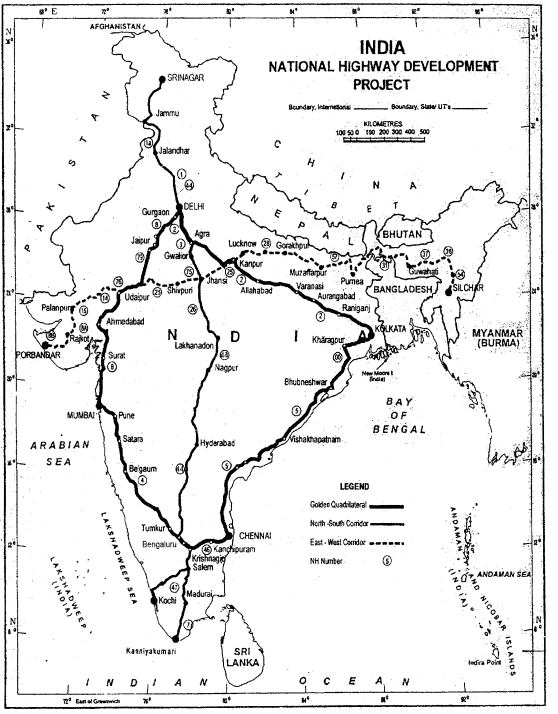
- Golden Quadrilateral: It comprises construction of 5,846 km long 4/6 lane, high density traffic corridor, to connect India’s four big metro cities of Delhi- Mumbai-Chennai-Kolkata. With the construction pf Golden Quadrilateral, the time-distance and cost of movement among the mega cities of India will be considerably minimized.
- North-South Corridors: North-South corridor aims at connecting Srinagar in Jammu and Kashmir with Kanyakumari in Tamil Nadu (including Kochi-Salem Spur) with 4,076 km long road.
- East-West Corridor: The East-West Corridor has been planned to connect Silchar in Assam with the port town of Porbandar in Gujarat with 3,640 km of road length.
Question 3.
Explain the functions of Border Roads Organisation.
Answer:
The Border Roads Organisation (BRO) was established in May, 1960.
Functions:
- It aimed at accelerating economic development and strengthening defence preparedness through rapid and coordinated improvement of strategically important roads along the northern and north-eastern boundary of the country.
- Border Road Organisation has completed over 40,450 km of roads by March, 2005.
- Apart from the construction and maintenance of roads in strategically sensitive areas, the BRO also undertakes snow clearance in high altitude areas.
Question 4.
Give the reasons for regional variations of the low density of roads in India.
Answer:
The reasons for low density of roads in India.
Nature of terrain:
- Construction of roads is easy and cheaper in plain areas.
- It is difficult and costly in hilly and plateau are better in plain areas.
- The density and quality of roads is relatively better in plain areas as compared to hilly areas, rainy and forested areas.
Level of economic development:
- Density and quality of roads is high in urban areas.
- It is very low in rural areas.
- Important towns are the nodes of north India.
Question 5.
What do you know about Konkan railway?
OR
What is the significance of Konkan railway?
Answer:
- One of the important achievements of Indian railways has been the construction of Konkan railway in 1998.
- It is 760 km long rail route connecting Roha in Maharashtra to Mangalore in Karnataka.
- It is considered as engineering marvel. It crosses 146 rivers, streams, nearly 2000 bridges and tunnels.
- Asia’s largest tunnel which is nearly 6.5 km long also lies on this route.
- States of Maharashtra, Goa and Karnataka are partners in this undertaking.
Question 6.
What is the importance of air transport?
Answer:
- It is easily accessible to places of uneven topography.
- It is important for transportation of perishable goods.
- It is the fastest means of transport which takes comparatively lesser time to make the passengers reach their destination.
- It is efficient during calamities.
- It has strategic importance also.
Question 7.
What is pipeline and why is it important?
Answer:
Pipeline is the cheapest means of transport as only once the construction has to be done and it has low operational cost. It is important because:
- It is the most convenient and efficient mode of transporting liquids and gases over long distances.
- It solves the problems of loading and unloading of raw materials and finished goods.
- This ensures the uninterrupted supply of raw materials to the refineries and finished products to the consumers.
- It is ideally suited for transport of liquids and gases.
- It can be laid through difficult terrain and underwater also.
- It involves low energy consumption.
- It rules out transhipment losses.
Question 8.
Explain the Super National Highways of India.
Answer:
- Golden Quadrilateral: It comprises construction of 5,846 km long 416 lane, high density traffic corridor to connect India’s four big metro cities of Delhi- Mumbai-Chennai-Kolkata. With the construction of Golden quadrilateral, the time-distance and cost of movement among the mega cities of India will be considerably minimised.
- North-South and East-West Corridors: North-South corridor aims at connecting Srinagar in Jammu & Kashmir with Kanyakumari in Tamil Nadu (including Kochi-Salem) with 4,076 km long road. The East-West corridor has been planned to connect Silchar in Assam with the port town of Porbandar in Gujarat with 3,640 km of road length.
Question 9.
What is Internet? What are its uses?
Answer:
Internet is one of the most effective and advanced personal communication system.
Uses:
- It enables the users to establish direct contact e-mail to get access to the world of knowledge and information.
- It is also used for e-commerce and carrying out money transactions.
- The internet is like a huge central warehouse of data, with detailed information on various items.
- It enables us with the basic facilities of direct communication.
Question 10.
What are National Highways? Give its three characteristics.
Answer:
The main roads which are constructed and maintained by the central government are known as National Highways.
Characteristics of National Highways are:
- These roads are meant for inter-state transport and movement of defence men and material in strategic areas.
- These also connect the state capitals, major cities, important ports, railways functions, etc.
- The length of the National Highways constitutes only two per cent of total road length but carry 40 % of road traffic.
Question 11.
What are border roads? How are they important for the country?
Answer:
Roads along the northern and north¬eastern boundary of India are known as border roads. The Border Road Organisation (BRO) was established in May 1960 for accelerating economic development and strengthening defence preparedness through rapid and coordinated improvement and suffers daily necessities to border areas.
Example; Roads in high altitude mountainous terrain joining Chandigarh with Manila. This road runs at an average altitude of 4,270 metres above the mean sea level.
Question 12.
When did air transport begin in India? Explain its present state.
Answer:
Air transport in India made a beginning in 1911 when airmail operation comm¬enced over a little distance of 10 km between Allahabad and Naini. But its real development took place in post¬independent period. The Airport Authority of India is responsible for providing safe, efficient air traffic and aeronautical communication services in the Indian Air Space. The authority manages 126 airports including 11 international, 86 domestic and 29 civil enclaves at defence air fields.
Question 13.
What are the limitations of the pipeline transport?
Answer:
- Pipelines are not flexible.
- The capacity laid cannot be increased.
- The security of pipelines is little difficult.
- The repair of underground pipelines is not easy and leakages cannot be detected easily
Long Answer Type Questions
Question 1.
Explain the factors affecting Indian Railways.
Answer:
The pattern of Indian railway network has been influenced by geographical, economic and political factors.
Geographical Factors: The North Indian plain with its levelled land, high density of population and rich agriculture presents the most favourable conditions for the development of railways. However, the presence of a large number of rivers makes it necessary to construct bridges which involve heavy expenditure.
There are practically no railways in the flood plains of many rivers in Bihar and Assam. The plateau region of south India is not as much suitable for railways as the North Plain area. The Himalayan region in the north is almost entirely devoid of railways due to its rugged topography.
Some railway terminals such as Jammu Tawi, Kotdwar, Dehradun, Kathgodam, etc. are found on the foothills. Some narrow gauge railway tracks are found in the Himalayan region. A railway link
between Jammu and Kashmir valley is being planned at a veiy high cost. The sandy areas of Rajasthan are also not much favourable for railways.
There was no railway line between Jodhpur and Jaisalmer till 1966. Similarly, forested areas of Madhya Pradesh and Odisha, deltaic swamps of West Bengal, marshy areas of Rann of Kachchh and hilly tract of Sahyadri are also unfavourable for the development of railways. Sahyadri can only be crossed through gaps like Thalghat, Bhorghat and Palghat to reach coastal trail heads like Mumbai, Vasco-de-Gama, Mangalore and Kochi. Obviously, the railways tend to follow the path of least resistance.
Economic Factors: Railways develop more in the economically advanced areas where the need for railway network is felt more. Conversely, railways bring about economic prosperity to the areas through which they pass. This is because of the economic linkages that we find the highest density of railways near big urban and industrial centres and in areas which are rich in mineral and agricultural resources.
Political and Administrative Factors: The present railway system in India is the legacy of the British rule. The British administration planned the direction and pattern of the railway lines in such a way that they could exploit the valuable raw materials of India for the benefit of their industries and flood the Indian markets with the finished goods from Britain.
Besides, the Britishers wanted to maintain their military supremacy, for which quick movement of troops and arms was necessary and construction of railways became unavoidable. Thus, top priority was given to the big ports of Mumbai, Kolkata and Chennai. These ports were connected with their hinterlands by railway lines to facilitate imports and exports. It is from the ports that the railway network spread to other parts of the country.
Question 2.
What recent steps have been taken for development and modernisation of Indian railways? Why is unification of gauges important? What role does railway network play in economic development of our country?
Answer:
Recent development and modernisation steps taken in Indian railways:
- Extensive programme to convert the metre and narrow gauge to broad gauge.
- The steam engines have been replaced by diesel and electric engines. .
- The new trains have increased speed.
- The environment of the stations have improved. There have been computerised reservations, automatic electronic signals, loading facilities, etc.
- Introduction of metro in Kolkata and Delhi have set an example for other states also.
- Railway routes have been extended to other areas such as Konkan railway between Mumbai and Mangalore.
- Improved passenger services on the trains include AC coaches, pantry services, bedding facilities, etc.
Unification of gauges is important:
- Unification of gauges will bring uniformity across the country.
- It helps in increasing capacity with broad higher speed.
- It provides higher speed at economical rates.
- Reduction in transhipment losses, eliminates wastage of time and money.
- Maintenance of single track is easy and it promotes comfortable travelling.
Contribution of Indian railways to economic development:
- The major bulk commodities transported by railways are coal, food grains, cement and fertilizers.
- The haulage of food grains increased to about four times between 1970-71 to 2004-05. It has now reached upto 44.07 million tons from 15.1 million tons.
- It shows production has substantially increased.
- The transport of fertilizers has increased many times from 4.7 million tons in 1970-71 to 23.7 million tons in 2004-05. It shows improvement in the agricultural sector as it provides the base for agri¬cultural development.
- The transport of coal has increased from 47.9 million tons in 1970-71 to 251.7 million tons in 2004-05. It shows the expansion of railways. Moreover, the consumption of coal has brought major industrial development.
Question 3.
Discuss the growth and role of TV and radio in mass communication.
Answer:
Radio: Radio broadcasting started in India in 1923 by the Radio Club of Bombay. Since then, it gained immense popularity and changed the social-cultural life of people. Government took mode of communication under its control in 1930 under the Indian Broadcasting System. It was changed to All India Radio in 1936 and to Akashwani in 1957 (TV).
Television: TV broadcasting has emerged as the most effective audio-visual medium for disseminating information and educating masses. Initially, the TV services were limited only to the national capital where it began in 1959. After 1972, several other centres became operational. In 1976, TV was delinked from All India Radio (AIR) and got a separate identity as Doordarshan (DD). After INSAT-IA (National Television-DDl) became operational, Common National Programme (CNP) was started for the entire network and its services were extended to the backward and remote rural areas. TV and radio play an important role in mass communication.
- All India Radio broadcasts a variety of programmes related to information, education and entertainment.
- Special news bulletins are also broadcast at specific occasions like session of parliament and state legislatures.
- They are used for the purpose of advertisement of various products.
- They are used to create awareness on government policies and programmes.
- They are also used to create awareness about various diseases and their precautions. In this way they act as public health measures.
- Weather forecasting information, important facts and figures reach to general public only through radio and TV.
Question 4.
Explain the primary and secondary inland waterways of India.
Answer:
India has 14,500 km of navigable waterways, contributing about 1% to the country’s transportation. It comprises rivers, canals, backwaters, creeks, etc. At present, 3,700 km of major rivers are navigable by mechanised flat bottom vessels. For the development, maintenance and regulation of national waterways in the country, the Inland Waterways Authority was set up in 1986.
The authority has declared inland national waterways:
National Waterway 1: Allahabad-Haldia stretch (1,620 km): It is one of the most important waterways in India. It is navigable by mechanical boats up to Patna and by ordinary boats up to Haridwar. It is divided into three parts for developmental purposes:
- Haldia-Farakka (560 km)
- Farakka-Patna (460 km)
- Patna-Allahabad (600 km).
National Waterway 2: Sadiya-Dhubri stretch (891 km): The Brahmaputra is navigable by steamers up to Dibrugarh (1,384 km) which is shared by India and Bangladesh.
National Waterway 3: Kottapuram-Kollam stretch (205 km): It includes 168 km of west coast canal along with Champakarcanal (23 km) and Udyogmandal canal (14 km). Inland Waterways Authority has also identified ten other inland waterways, which could be upgraded. The backwaters (Kadal) of Kerala has special significance in Inland Waterway. It provides cheap means of transport and also attracts a large number of tourists in Kerala. The famous Nehru Trophy Boat Race (VALLAMKALI) is also held in the backwaters.
National Waterway 4: specified stretches of Godavari and Krishna rivers alongwith Kakinada, Puducherry stretch of canals (1078 km).
National Watery-5: Specified streches of Brahmani along with Matai river, delta channels of Mahanadi & Brahmani rivers and East Coast Canals (588 km).
Question 5.
Explain the functions of Oil India Limited (OIL).
Answer:
Oil India Limited (OIL) operates under the administrative set up of the Ministry of Petroleum and Natural Gas. It is engaged in the exploration, production and transportation of crude oil and natural gas. It was incorporated in 1959 as a company.
Functions:
- It constructed Asia’s first cross country pipeline covering a distance of 1,157 km from Naharkatiya oilfield in Assam to Barauni refinery in Bihar.
- It was further extended up to Kanpur in 1966.
- It has also constructed another pipeline in the western region of India of which Ankleshwar-Koyali, Mumbai High- Koyali and Hazira-Vij aipur-Jagdishpur (HVJ) are most important.
- Recently, a 1256 km long pipeline connecting Salaya (Gujarat) with Mathura (U.P.) has been constructed.
- It supplies crude oil from Gujarat to Punjab (Jalandhar) via Mathura.
- OIL is in the process of constructing of 660 km long pipeline from Numaligarh to Siliguri
Higher Order Thinking Skills (HOTS)
Question 1.
Why is the density of rural roads very low in hilly, plateau and forested areas?
Answer:
Due to the following factors, the density of rural roads is very low in hilly, plateau and forested areas.
- Technological difficulty in construction
- Low population density.
- Relatively lesser economic activity.
- Costs of construction are relatively higher.
- Settlements are located far away from each other.
Question 2.
“Among all the personal communication systems internet is the most effective and advanced one.” Do you agree with the statement?
Answer:
I agree with the statement because:
- It enables the users to establish direct contact.
- It is widely used in urban areas.
- It acts like a huge central warehouse of data and other information.
- It provides an efficient access to information at relatively low cost.
- It is increasingly used for e-commerce and many transactions.
- It is the most time efficient device.
Question 3.
Inspite of numerous rivers, why are India’s inland waterways poorly developed?
Answer:
Inspite of numerous rivers, India’s inland waterways are poorly developed because:
- Seasonal fluctuations in the volume of water level of most rivers.
- Higher silting in the river bed.
- Reduction in water level due to diversion of water for irrigation.
- Floods and swift currents.
- Tough competition from roads, railways and transport with regard to convenience.
- Lack of mechanised vessels.
- Undulating topography.
Question 4.
Why has the container transport become more popular nowadays?
Answer:
Container transport has become very popular nowadays because:
- It provides door to door service.
- It has reduced transport and delivery time.
- The service is economical both to the railways and its customers.
- Safety and security of product.
Question 5.
How have geographical factors influenced railway network in India?
Answer:
The North Indian plain with its level land, high density of population and rich agriculture presents the most favourable conditions for the development of railways. However, the presence of a largo number of rivers makes it necessary to construct bridges which involve heavy expenditure.
There are practically no railways in the flood plains of many rivers in Bihar and Assam. The plateau region of south India is not as much suitable for railways as the North Plain area. The Himalayan region in the north is almost entirely devoid of railways due to its rugged topography.
Some railway terminals such as Jammu Tawi, Kotdwar, Dehra Dun, Kathgodam, etc. are found on the foothills. Some narrow gauge railway tracks are found in the Himalayan region. A railway link between Jammu and Kashmir valley is being planned at a very high cost. The sandy areas of Rajasthan are also not much favourable for railways.
There was no railway line between Jodhpur and Jaisalmer till 1966. Similarly, forested areas of Madhya Pradesh and Orissa, deltaic swamps of West Bengal, marshy areas of Rann of Kachchh and hilly tract of Sahyadri are also unfavourable for the development of railways. Sahyadri can only be crossed through gaps like Thalghat, Bhorghat and Palghat to reach coastal trail heads like Mumbai, Vasco-de-Gama, Mangalore and Kochi. Obviously, the railways tend to follow the path of least resistance.
Social-Cultural significance of Roads:
Higher road density affects the society and cultural of a region. Kerala’s high density of roads can be linked to it’s highest HDI
ranking in India:
The literacy rate of 94% as children can easily travel to reach schools The infant mortality rate is low, as medical help is easily accessible, due to high road density. Longevity is higher as sick can easily reach the doctors & hospitals. The higher road density, allows people to travel more, thus make them more aware of medical facilities to control population growth & birth rate. Kerala has linear & continuous settlement pattern along the roads, where one village ends & another one begins.
Differentiates
Question 1.
Differentiate Between National Highways and State’ Highways
Answer:
Basis | National Highways | State Highways |
Construction | These are constructed and maintained by the central government. | These are constructed and maintained by state govemmet. |
Purpose | These are meant for interstate transport and connect the state capital’s major cities, important ports, railways junctions, etc. | They join the state capitals with district headquarters and other important towns. These roads are connected to the National Highways. |
Share in road length and road traffic | They constitute only 2% of total road length but carry 40% of road traffic. | They constitute 4% of total road length in the country. |
Question 2.
Differentiate Between District Roads and Rural Roads
Answer:
Basis | District Roads | Rural Roads |
Construction | These are constructed and maintained by state government. | These are constructed and maintained by local government. |
Purpose | These roads are the connecting link between District Headquarters and the other important nodes in the district. | These roads are vital for providing links in the rural areas. |
Share in road length | They account for 14 per cent of the total road length of the country. | About 80 per cent of the total road length in India are categorized as rural roads. |
Question 3.
Differentiate Between Meter Gauge, Broad Gauge and Narrow Gauge
Answer:
Basis | Meter Gauge | Broad Gauge | Narrow Gauge |
Breadth | The distance between rails is one metre. | The distance between rails in broad gauge is 1.676 metre. | The distance between the rails in this case is 0.762 metre or 0.610 metre. |
Share in total route length | It runs over 13,290 km covering 21.02 per cent of the total route length. | The total length of broad gauge lines is 46,807 km which accounts for 74.14 per cent of the total length of rail routes in the country. | Nearly 4.94 per cent of the total length of the Indian Railways is narrow gauge, which accounts for 3,124 km of route length. It is generally confined to hilly areas. |
Question 4.
Differentiate Between Air India and Indian Airlines
Answer:
Basis | Air India | Indian Airlines |
Service | It provides overseas air transport. | It provides domestic air transport. |
Purpose | Air India provides International Air services for both passengers and cargo traffic. It connects all the continents of the world through its services. | It is country’s largest state-owned domestic carrier, Indian Airlines dropped the word ‘Airlines’ from its name and is known as ‘Indian’ w.e.f. December 8, 2005. |
Share in air traffic | In 2005, it carried 12.2 million passengers and 4.8 lakh metric tonnes of cargo. | In 2005, domestic movement involved 24.3 million passengers and 20 lakh metric tonnes of cargo. |
Question 5.
Differentiate Between Personal Communication and mass communication
Answer:
Basis | Personal Communication | Mass Communication |
Purpose | When communication takes place between two or more persons at personal level, i.e. either orally or in writing but the persons interacting have a personal involvement, it is called personal communication. | When communication takes place for public at large or when a means is used to convey a message to many people simultaneously, it is called mass communication. |
Means | Telephone, email, letter, fax, oral face to face interaction. | Radio, TV, newspaper, magazines, internet, etc. |
Map Based Questions
Question 1.
Locate and label the following on the political map of India.
(i) Tower on north-south and east-west corridors.
(ii) Golden Quadrilaterals
Answer:
Question 2.
Locate and label the following on the political map of India.
Mumbai CST, Kolkata, Hajipur, Bhubaneshwar, New Delhi, Allahabad, Gorakhpur, Maligaon, Jaipur, Chennai, Secunderabad, Kolkata, Bilaspur, Hubli, Mumbai (church gate), Jabalpur.
Answer:

Important Questions
Very Short Answer Type Questions:
Question 1.
What is the main aim behind establishing border road organization in India? (Delhi 2008)
OR
State the main functions of border road organization. (A.1.2013)
Answer:
Border Road Organisation was established for accelerating economic development and strengthening defence through rapid and coordinated improvement of strategically important roads along the northern and north-eastern boundary of the country.
Question 2.
Name the air service which is widely used in the hilly areas of the north¬eastern sector of India. (A.I. 2011)
Answer:
Pawan Hans.
Question 3.
State the main function of ‘National Highways Authority of India’ (NHAI). (A.I. 2013)
Answer:
The main function of National Highways Authority is development maintenance and operation of National Highways.
Question 4.
Define the term ‘road density’. (Delhi 2014)
Answer:
Road density is the length of roads per 100 square km of area.
Question 5.
Why did Sher Shah Suri built the Shahi (Royal) Road? (Delhi 2015)
Answer:
Sher Shah built the Shahi (Royal) road to strengthen and consolidate his empire from the Indus Valley to the Sonar Valley in Bengal.
Question 6.
What is the major function of the National Highways Authority of India?
Answer:
Major function of the National Highway Authority of India is: Operation, maintenance and development of National Highways.
Question 7.
Why did Sher Shah Suri built the Shahi (Royal) Road? (CBSE 2018)
Answer:
Sher Shah built the Shahi (Royal) road to strengthen and consolidate his empire from the Indus Valley to the Sonar Valley in Bengal.
Short Answer Type Questions:
Question 1.
Classify satellite system of India into two groups on the basis of configuration and purpose. Explain the main feature of each group. (Delhi 2009)
Answer:
On the basis of configuration and purposes satellite system in India is divided into two types
Indian National Satellite System (INSAT):
- It was established in 1983.
- It is a multi-purpose satellite system for telecommunication, meteorological observation.
Indian Remote Sensing Satellite System (IRS):
- With the launching of IRS-IA in March 1988 from Vaikanour in Russia, it became operational.
- It collects data in several spectral bands and trasmit them to the ground stations for various uses.
- It is useful in the management of natural resources.
Question 2.
‘The density and the quality of roads are better in plains as compared to other regions in India.” Support this statement with examples. (A.I. 2009)
Answer:
The density and the quality of roads are better in plains as compared to other regions in India because:
- Nature of terrain and the level of economic development are the main determinants of density of roads.
- Construction of roads is easy and cheaper in the plain areas while it is difficult and costly in hilly and plateau areas.
- Example; Density of roads in J & K is 10.04 km while in Uttar Pradesh it is 532.27 km with a national average of 125.02 in 2008.
Question 3.
Describe any three advantages of water transport in the world. (A.I. 2013)
Answer:
- It does not require route construction.
- Oceans are linked with each other.
- They are negotiable with ships of various sizes.
- It is much cheaper than other means of transport.
- The friction of water is far less than that of land.
- The energy cost of water transportation is lower.
Question 4.
What do you mean by satellite communication? (A.I. 2014)
Answer:
Communication through artificial satellites launched in space is called satellite communication. It has emerged as a new area in communication technology since the 1970’s after the U.S.A. and former U.S.S.R. pioneered space research. In other words, it is an electronic network of computer which connects million of people across the world. It is the result of digitalisation of information in which the telecommunication is merged with computers.
Question 5.
Explain any three benefits of satellite communication in India. (Delhi, 2014)
Answer:
Three benefits of satellite communication in India are as follows:
- Satellite images can be used for the weather forecast, monitoring of natural calamities, surveillance of border areas, etc.
- It can be used as multi-purpose system for telecommunication, meteorological observation and for various other data and programmes. The IRS satellite system became operational with the launching of IRS-IA in March, 1988 from Vaikanour in Russia.
- The National Remote Sensing Agency (NRSA) at Hyderabad provides facilities for acquisition of data and its processing. These are very useful in the management of natural resources.
Question 6.
Describe any three features of Konkan ; Railway. (Delhi, 2017)
Answer:.
Features of Konkan Railways:
- One of the achievements of Indian Railways.
- It is 760 km. long.
- It crosses 146 rivers, 2000 bridges approximately and 91 tunnels.
- Asia’s largest tunnel lies in this route.
-
It connects Roha in Maharashtra to Mangalore in Karnataka.
(Any three features to be described)
Long Answer Type Questions:
Question 1.
Define the term ‘road density’. Explain with examples the two main determinants of road density in India. (Delhi 2011)
OR
Explain with five suitable examples, how the level of economic development and nature of terrain affect the density of roads in India.(Delhi 2013)
Answer:
Road density is the length of roads per 100 sq. kms of an area. Determinants of road density are level of economic development and nature of terrain.
- Construction of roads is easy and cheaper in the plain areas while it is difficult and costly in hilly and plateaus areas.
- Jammu and Kashmir has only 10.48 km. road density while Uttar Pradesh 532.27.
- The road density is high in most of the northern states and major southern states.
- It is low in the Himalayan region, northeastern region, Madhya Pradesh and Rajasthan.
- Not only the density but also the quality of roads is relatively better in plains as compared to roads in high altitude areas, rainy and forested regions.
Question 2.
‘Indian railways brought people of diverse cultures together.” Support this statement with suitable examples. (Delhi 2015)
Answer:
Indian Railways brought people of diverse cultures together as
- It was introduced in 1853, when a line was constructed from Bombay to Thane covering a distance of 34 km.
- Its network is more than 644060 (2011) kms which is spread in different states.
- It connects people of different regions through its sixteen (16) zones.
- It facilitates the movement of both fright and passengers and contributes to the growth of economy.
- People from different languages, customs and food habits could connect with each other through Indian Railways. By this people of different languages and customs meet and a mix culture is developing and India is developing as a “Nation” from “Federation of States.
Question 3.
Examine the role of Inland Waterways Authority of India. Explain why inland water transport is an important mode of transport. (A.1.2016)
Answer:
Inland water is an important mode of transport because:
- It was the chief mode of transport before the advent of railways.
- It contributes about 1% of the country’s transportation.
- It provides cheap means of transport.
- It also attracts large member of tourists.
Question 4.
Explain why rail transport continues to remain the chief mode of transport for the masses in India. (A.I. 2016)
Answer:
Rail transport continues to remain the chief mode of transport for the masses in India because:
- It facilitates the movement of both fright and passengers.
- It contributes to the growth of the economy of the country.
- Indian Railway has convert the metre and narrow gauges to broad gauge.
- It is also the cheap means of transport.
- Metro rail has revolutionized the urban transport system in Kolkata and Delhi.
Question 5.
Explain any five factors responsible for the development of ‘Mumbai-Pune Industrial Region’. (Delhi 2017)
Answer:
Factors responsible for the development of ‘Mumbai-Pune Industrial Region:
- Favorable climatic conditions for the development of cotton textile industries.
- Opening of the Suez Canal providing impetus for its growth.
- Availability of port facility for trade.
- Development of hydro-electricity in Western Ghats.
- Availability of labour.
- Nearness to off-shore oil fields favored the growth of petrochemical industries.
-
Growth and development of various industries e.g. engineering goods, pharmaceuticals, chemicals etc.
(Any five points to be explained)
Question 6.
Classify means of communication on the basis of scale and quality into two categories. Explain any two characteristics of each category. (A.I. 2017)
Answer:
Classification of means of communication on the basis of scale and quality:
- Personal Communication
- Mass Communication
Characteristics:
Personal Communication System:
- Internet is the most effective advanced one and widely used in urban areas.
- It enables the user to establish direct connect through Email to get access to world of knowledge and information.
- It is used for e-commerce and carrying out money transaction.
- It is a huge central warehouse of data, with detailed information on various items. (Letters, Telephone, Fax, Email, Internet, etc).
Mass Communication System:
- Radio broadcasting started in India in 1923 by the Radio Club of Bombay and changed the socio¬cultural life of people.
- Television broadcasting emerged as the most effective-audio-visual medium for information and educating masses.
-
Use of satellite and synoptic view of larger area for economic and strategic reasons. (Radio, Television, Cinema, Satellite, News Paper, Magazine and Books, Seminar and Conference, etc).
( Any two points )
Question 7.
Describe any five characteristics of National Highways of India. (Delhi 2018)
Answer:
Characteristics of National Highwaysof India:
- Constructed and maintained by the Central Government.
- Meant for inter-state transport.
- Meant for movement of defence men and material in strategic areas.
- They connect the cities in different parts (state capitals, major cities, important ports, railway junctions) of India.
- They constitute 1.7% of total road length and 40% of the road traffic in India.
- NHAI is entrusted with the responsibility of development, maintenance and operation of NH.